
Better field mapping makes a faster decision making possible. Mapping from above is a big help to create the best overview. Agrinavia MAP provides you – among a number of other clever and up-to-date solutions – with this functionality.
Agrinavia MAP is developed especially for agricultural use and is optimized to work with Google orthophotos.
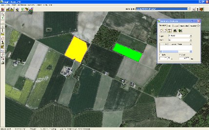
The program has been on the market for more than 15 years and is currently the most widely used mapping program among farmers and agricultural advisors in Denmark and Sweden. The program works integrated with Agrinavia FIELD and other programs on the market and can be customized.
Using Agrinavia MAP you can:
- Measure field size
- Present field records
- Print presentable field maps
- Edit areas
- Print field maps for subsidy applications
- Enter other information, such as drainage maps
- Work with digital drainage maps
- Expand mapping program with GPS modules
- Bring your field MAP to your field using your mobile phone
- Allow modulation of lime, fertilizers, seeds, etc.
Agrinavia MAP combined with several individual modules:
Using Agrinavia MAP you have the opportunity to ad several modules to extent your use of the program.
- Several users
- Several farms
- Farm Site Mate
- Analysis /registration of the results from soil samples.
Languages
Agrinavia MAP is available in the following languages: